6.5.0 Dec 10, 2025
paid for free
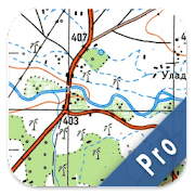
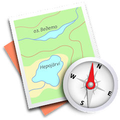
Soviet Military Maps is an excellent mobile map application designed for off-road trips, adventurous travels, and expeditions. Whether you are planning a cross-country journey to the Sahara Desert or a trekking tour in the Himalayas, the Russian topographic maps offer a reliable alternative to other map sources. They provide detailed topography, including many small trails and unpaved roads that may be absent from other map sets.
These Russian maps also come with additional English labels for ease of use.
Important Notice: The Soviet Military Maps were primarily created in the 1980s and may not be very relevant for industrialized countries. Outside Africa and Asia, you may find OpenStreetMap (OSM) or Google Map layers more practical.
Please note that this app does not offer direct turn-by-turn navigation; however, you can easily switch to Google Navigation via selected waypoints.
The Russian Topo Maps Pro provides off-road navigation with topographic maps from around the world, predominantly sourced from the Russian General Staff. For many regions in Africa and Asia, these maps are still among the best available topographic resources.
Topographic Maps Worldwide
(1:100K - 1:500K seamless coverage)
Google Maps
(satellite imagery, road maps, terrain maps)
OpenStreet Maps
(including OSM Mapnik, Osmarender, and Cloudmade Cyclemap)
Similar to Garmin and Magellan handheld GPS devices, this application offers various mapping options.
Offline tile downloading of maps (not applicable to Google Maps)
Creation and editing of waypoints
Navigation to waypoints
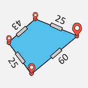
Track recording (with speed and elevation profiles)
Tripmaster displaying fields such as odometer, average speed, course, altitude, etc.
GPX Import/Export, KML Export
Search function (toponyms, points of interest, streets)
Customizable data fields for viewing on the map and Tripmaster (e.g., speed, distance, compass)
Waypoint/Track sharing (via email, Facebook, etc.)
And many more...
This off-road/offline navigation app includes worldwide topographic maps, mainly from the Russian military archives. Many maps for countries in Africa and Asia are regarded as some of the best available topomaps.
Scale 1:100,000
Coverage for Europe, Afghanistan, Azerbaijan, Georgia, Japan, Jordan, Latvia, Lithuania, Kazakhstan, Kyrgyzstan, Morocco, Mongolia, Pakistan, Russia, Syria, Tajikistan, Turkey, Turkmenistan, Ukraine, Uzbekistan, Belarus.
Scale 1:200,000
Covers various countries including but not limited to Afghanistan, Egypt, Algeria, Angola, Argentina, and more.
Scale 1:250,000
*(Local maps from USGS, Geoscience Australia, CTIO)*:
United States, Canada, Australia.
Scale 1:500,000
Applied to all other countries not listed above.


ParKing Premium: Find my car - MOD APK
Air Traffic - flight tracker MOD APK
MapTiler MOD APK
Jakdojade: public transport MOD APK
Spyglass MOD APK
Route Recorder MOD APK
Live Earth Map - World Map 3D MOD APK
ActiMap - Outdoor maps & GPS MOD APK
Sygic Car Connected Navigation MOD APK
Easy Area : Land Area Measure MOD APK

Navigation Pro: Maps on Watch MOD APK
Trekarta - offline outdoor map MOD APK
Russian Topo Maps Pro MOD APK
Qibla Finder - Qibla Direction MOD APK

Moovit: Bus & Train Schedules MOD APK

MarineTraffic - Ship Tracking MOD APK

Find parked car - Parking spot MOD APK

SmartDriver: Radar Detector MOD APK

calimoto — Motorcycle GPS MOD APK

Speed Camera Radar: AntiPolice MOD APK